Wine Weather: La Niña Drives New Zealand’s Summer 2025–26
Heatwaves, flooding, thunderstorms. La Niña has strongly influenced our summer weather again as 2025 closes and we charge headlong into 2026.
 increase font size
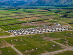
 Two Terraces
With the exception of a heat event during early January that brought some record breaking temperatures to the east coast of the North Island, it has been a very average summer and early autumn for most of the country.
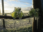
A moderate La Niña has provided higher than average humidity and reduced sunshine at times for eastern regions. The lack of westerlies has contributed significantly to fewer 30C days in most regions. Rainfall totals have been above average in some regions, especially Canterbury. La Niña generally brings increased cloud cover and milder nighttime temperatures for eastern areas, but a couple of cool mornings in late February did see temperatures fall below 1C in parts of Central Otago on the 23rd and also below 3C about parts of Marlborough on the 23rd and again on the 28th.
A "Super" El Niño?
Superlatives are often an attention-grabbing headline when the weather or climate drivers are pointing to significant extremes. We hear of ‘Heat Domes’, ‘Atmospheric Rivers’ and ‘Polar Vortex’, to name a few. ‘Weather Bomb’ is often misappropriated as a colloquial phrase for a rapidly deepening low pressure system. A ‘Bomb’ low is where air pressure drops by 24 millibars or more over a 24 hour period and can signal very destructive storms over land and sea. The rising threat of climate change means that the weather events that occur at the ends of the weather spectrum are increasing, and unfortunately it is likely that we will continue to see these phrases dominating the weather news headlines. Without delving too deep into the uncertain future of our climate, there is another weather headline heralding the arrival of a change in weather patterns for New Zealand. That is El Niño, and the possibility that it may develop into what is being termed a ‘Super El Niño’. Even more recently there have been murmurings (ECMWF in Europe) that this El Niño may become so strong that it could be given the moniker of ‘Goliath El Niño’
While its final shape and size is yet to be seen, a ‘Super’ or ‘Goliath’ El Niño would have to be similar in strength to the 1997-98 and 1982-83 El Niños. These events both lead to significant droughts along the east coast of much of New Zealand. Summer was virtually non-existent in Wellington and Southland in 1982-83, as those regions were battered by constant westerlies or north westerlies. In 1997-98, Wellington saw a much milder summer, which highlights how other climate drivers can impact the weather during a strong El Niño or La Niña. With the latest swing in the Southern Oscillation likely to take place during winter, we should see a windier and often unsettled spring later in 2026.
It is still too early to know, but current projections are offering a 33% chance that El Niño will be strong by the end of 2026. There is also significant variation in long range modelling, so while we have an idea of the primary climate driver for the remainder of 2026, it will be wait and see for the next few months before we can determine how influential it will be.
Outlook for April and May:
Gisborne/Hawke's Bay - Temperatures should remain near average through April but may remain above average into May, as sea surface temperatures remain above average around the upper North Island. Nighttime minimums are more likely to remain above average, with increased cloudiness at times. As westerlies return, an increase in the diurnal range is expected. Rainfall totals are likely to be near average, but there is still a risk of a late ex-tropical system bringing significant rain to the east coast.
Wairarapa - Mean temperatures remain close to average. April may see an increase in windiness as north westerlies start to return. Rainfall totals again will run close to average or possibly above average for the remainder of autumn.
Nelson - A more persistent northerly flow should keep minimum temperatures a little above average but it may supress daytime temperatures a little. Rainfall totals are expected to be close to average, with an increased likelihood of meaningful rain arriving from Tasman Sea frontal systems.
Marlborough/North Canterbury - Mean temperatures remain close to average. Again it is likely that overnight temperatures will run a little above normal and there may also be an increase in foggy mornings. Rainfall totals are likely to be close to average, especially about Marlborough. North Canterbury also has an increased risk of more significant rain arriving from any late season depressions with a strong onshore easterly flow.
Central Otago - Mean temperatures are likely to run near or above average, in part due to a persistent northerly flow. Colder southwest changes may increase in frequency through May and bring large swings in temperature. Rainfall is expected to be near or below average. West to northwest winds may also increase in frequency through the second half of autumn.
James Morrison runs Weatherstation Frost Forecasting: weatherstation.net.nz
Heatwaves, flooding, thunderstorms. La Niña has strongly influenced our summer weather again as 2025 closes and we charge headlong into 2026.
Many regions have experienced a wet, cloudy and grey winter.
After record breaking cold for some regions at the start of 2025 (I'm looking at you Wairarapa), there has been a steady improvement in temperatures across the country through March, and then record-breaking warmth for many parts of New Zealand during April.
I am writing this story with the 2025 harvest in full swing.