Wine Weather: La Niña Drives New Zealand’s Summer 2025–26
Heatwaves, flooding, thunderstorms. La Niña has strongly influenced our summer weather again as 2025 closes and we charge headlong into 2026.


 increase font size
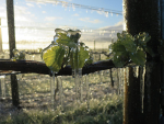
 Pegasus Bay
It has been a warm and often wet autumn across Aotearoa this year.
The early signs of El Niño have given rise to the revival of the long-forgotten westerlies, but La Niña has been firing a few parting shots, with some remarkably warm temperatures setting records all over the country. Rain has not been in short supply in most regions but this may not last in the second half of 2023. El Niño tends to bring warmer than average temperatures around the globe but a growing concern has been the steady rise in sea surface temperatures.
What's up with El Niño?
Sea surface anomalies across the equatorial Pacific are showing the tell-tale signs of El Niño. It is now increasingly likely that El Niño will develop over the southern hemisphere winter and continue into early 2024. The seasonal effects on our part of the world include westerly winds, which are likely to become more dominant through the second half of winter and into spring. Historically, a spring El Niño brings a marked increase in westerly winds, both in predominance and strength. The lower North Island and upper South Island are often the receiver of these strong winds, but gales or strong winds also occur from Hawke's Bay to Southland. The change in direction will also signal a change in where our 'active' weather comes from. Fronts and low pressure systems approaching from the west should see rainfall increase in the west of both islands and the east is likely to become much drier. The drying out of the east coast of both islands could start as early as July and last through until the end of the year.
Other weather drivers such as the Southern Annular Mode and Madden-Julian Oscillation (MJO) may also have some bearing on how much the traditional traits of El Niño impact us over winter and spring.
Sea Surface Temperatures
Every day thousands of temperature sensors in our oceans are measuring the temperature at the surface. These readings are taken from a variety of sources such as jetties, buoys and ships. Satellites are also measuring our oceans down to a fine detail. As the network of observations increases we gather a greater understanding of the role that the ocean plays in our climate. Over the past five years, sea surface temperatures (SST) around New Zealand have been above the long term average nearly every month. Latest SST forecasts are picking them to remain above average for the foreseeable future. SST are running around 1C-2C above average in our surrounding seas and this is one of the indications that winter temperatures are likely to run near or above average this year.
Outlook for June and July
Gisborne/Hawke's Bay
The ghost of La Niña may linger for a few more weeks through June, but conditions should start to dry out later in July as southwest winds become more frequent. Mean temperatures remain above average, but nighttime minimums may slide back towards average in July. Rainfall totals are likely to be near average, but totals may reduce later in July as El Niño strengthens.
Wairarapa
Mean temperatures are likely to remain a little above average through June and July, but nighttime minimums may fall back to normal in July. Rainfall is likely to be close to average, with a variety of sources. An increase in southerly conditions will bring rain and some colder daytime maximums. An increase in stronger northwest winds may start to occur in late July.
Nelson
Once again temperatures are likely to remain above average. Nighttime minimums are likely to drop close to average in July as southerly winds increase and northerlies decrease. Rainfall may be near normal at first, but may fall below average in July.
Marlborough/North Canterbury
Mean temperatures are set to follow the national trend and remain above average. Cold southerly changes are expected from time to time and these are likely to be followed by frosts and colder nights. Rainfall totals may be close to average through June but could fall below average in July as El Niño starts to ramp up.
Central Otago
Mean temperatures are likely to run near or a little above average through early winter. There may be an increase in colder southerly outbreaks that are followed by frosty conditions, due in part to El Niño. Later in winter there is a chance that westerly winds will start to ramp up and this may increase the speed in which weather systems cross the lower South Island. This means late winter could become less settled and quite changeable.
James Morrison runs Weatherstation Frost Forecasting: weatherstation.net.nz
Heatwaves, flooding, thunderstorms. La Niña has strongly influenced our summer weather again as 2025 closes and we charge headlong into 2026.
Many regions have experienced a wet, cloudy and grey winter.
After record breaking cold for some regions at the start of 2025 (I'm looking at you Wairarapa), there has been a steady improvement in temperatures across the country through March, and then record-breaking warmth for many parts of New Zealand during April.
I am writing this story with the 2025 harvest in full swing.


OPINION: 2020 unleashed Covid-19, and in 2021 we saw the smallest vintage in the past decade – for many wineries, tanks…

OPINION: Every vintage has it’s vagaries, and every season I am struck by how nimble viticulturists, winemakers and grape growers…
Jimmy Stewart is quite literally chipping away at circularity.
A Wine Marlborough Lifetime Achievement Award is “very premature”, say Kevin and Kimberley Judd, nearly 43 years after they came…
From the heights of tramping tracks to the depths of picnic baskets, a Banks Peninsular winemaker wants his wines to…