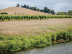
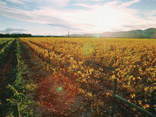
Wine Weather: La Niña Drives New Zealand’s Summer 2025–26
Heatwaves, flooding, thunderstorms. La Niña has strongly influenced our summer weather again as 2025 closes and we charge headlong into 2026.


 increase font size
 Pegasus Bay
Shortly after writing my last story about the weather in Aotearoa, the nation was slammed by two massive rain events.
The first being a low that was cut off and became stationary, driving a massive amount of warm moisture laden air over Auckland. The second was the disastrous Cyclone Gabrielle that has now added to the long list of storms that have caused flooding and major damage to the Gisborne and Hawke’s Bay regions.
Weather and climate has been my passion since I was young. I always dreamed of being able to write about the weather for a living. From taking manual weather observations in the backyard at home with a temperature screen that my grandfather built, to writing climate analysis and helping the viticulture industry battle frost, I have been so fortunate to have had the opportunities that have brought me to where I am today.
I began frost forecasting in 2006 in Hawke’s Bay and I want to acknowledge the growers who took a chance on my forecasts all those years ago, as well as every grower across the country I have worked with during the past 17 seasons. I am forever grateful to have had such a long and enjoyable time doing the job I love. I know how tough and resilient the people of Hawke’s Bay and Gisborne are and I hope to be able to do my part to help as 2023 progresses.
An emerging El Niño?
At long last we are seeing signs that the three year La Niña may finally be over. Sea surface temperatures are indicating a warming along the equator and western coast of South America that is a trademark of El Niño. Westerly winds are making a comeback and appear to be on the cards for much of autumn. It is not locked in that El Niño will form during winter in 2023, but the signs suggest that at the least we will move into a neutral phase and probably not back to La Niña for a fourth term. The Southern Oscillation Index (SOI) has fallen significantly (remember, the SOI is a comparison of the air pressure at Darwin and the air pressure at Tahiti). A negative SOI phase is related to El Niño and is when there is below normal pressure at Tahiti and higher than normal pressure at Darwin. During La Niña the opposite occurs. With higher than average air pressure over Darwin there is an increased risk of drought in southeast Asia and often an increased westerly flow over New Zealand. Strong El Niño such as those in 1982 to 1983 brought persistent westerlies and caused severe drought in eastern regions.
Autumn in 2023 could see a bumpy transition into winter with the lingering effects of a declining La Niña and the move into a possible El Niño. We are still likely to see occasional periods of humid, warm northeasterlies but after a long absence we are also likely to see some quite cold southerly changes.
Outlook for April and May
Gisborne/Hawke's Bay
An increased westerly flow is likely to see drier conditions increase as we move towards winter. The South Pacific cyclone season runs into April so there is always potential for another storm to bring rain and wind to the east coast. Because of this, rainfall totals are likely to remain near average or average until the end of May. Mean temperatures are likely to stay above average with day time maximums above normal. A few late hot days are possible under northwest conditions. Night time temperatures are likely to fall close to average by May and there is a risk of temperatures falling close to freezing later in April on the back of any fast clearing southwest changes.
Wairarapa
A bit closer to Cook Strait, the lower North Island can become quite windy as the westerly flow redevelops. Wairarapa may see a few windy days through autumn as a result. However, this is likely to be quite mixed and there is still a risk of a low from the tropics bringing back the easterlies and rain. Overall, rainfall totals are likely to be near average but could be lower in May. Mean temperatures should continue to run above average and like Hawke’s Bay there is a risk of frost late in April if the flow turns back to the southwest.
Nelson
Warm sea surface temperatures have helped to keep night time temperatures well above average in Nelson. This is likely to continue for much of autumn however areas that are well away from the coast will have a greater risk of frost late in April. Mean temperatures are likely to remain above average through into early winter. Rainfall is likely to be close to average.
Marlborough/North Canterbury
Sea surface temperatures remain well above average around the South Island and this is contributing to temperatures running above average in Marlborough and Canterbury. With growing signs of the demise of La Niña, there is likely to be a return to the classic nor’wester at times for both regions and this could produce a few very warm autumn afternoons. La Niña is not completely finished yet so there remains a chance of a sub-tropical low bringing cloud, rain and high humidity. Rainfall totals should be close to normal but may start to drop during May. As colder air from the Southern Ocean gets pulled up over the South Island there is a risk of frost on the back of any southwest changes.
Central Otago
Mean temperatures should remain above normal through autumn with milder than average day time maximums. There is also a risk of frost on the back of any cold changes. Increased westerlies and warm sea temperatures fronts crossing the lower South Island from the west may produce some reasonable rainfall at times. Rainfall totals are expected to be near average through into late autumn.
James Morrison runs Weatherstation Frost Forecasting: weatherstation.net.nz
Heatwaves, flooding, thunderstorms. La Niña has strongly influenced our summer weather again as 2025 closes and we charge headlong into 2026.
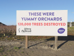
Nearly three years on from Cyclone Gabrielle, Hawke's Bay apple orchardist Paul Paynter says they are still doing remedial work around their orchards and facing financial challenges.
A stratospheric warming over Antarctica occurred during August.
If there was a silver lining in the tragedy that was Cyclone Gabrielle, for New Zealand Young Grower of the Year, Grace Fulford, it was the tremendous sense of community and seeing first-hand what good leadership looks like.
Many regions have experienced a wet, cloudy and grey winter.


Trade is important to our industry, whether it’s because 90% of our wine sales are in international markets, because of…

The end of the year is fast approaching, so here are some thoughts on a few of the significant developments…
Jimmy Stewart is quite literally chipping away at circularity.
A Wine Marlborough Lifetime Achievement Award is “very premature”, say Kevin and Kimberley Judd, nearly 43 years after they came…
From the heights of tramping tracks to the depths of picnic baskets, a Banks Peninsular winemaker wants his wines to…